
 Yahoo Sports
 How big are Israel and Gaza? Smaller than you might think
If you haven’t visited Israel or the Gaza Strip or spent much time thinking about their geography, it can be hard to understand how compact they are and how violence in one spot can feel immediate and personal throughout the area.
Maps of the region often look like this: Israel fills the frame. To people who are used to looking at maps of the United States, there seems to be plenty of space between major cities.
But America is vast. A road trip across the continental U.S. takes days. For a solo driver who needs to rest, it can last a week. Driving across the broadest part of Israel, meanwhile, from its northernmost point to its southernmost tip, takes less than six hours. There’s barely a need for a bathroom break.
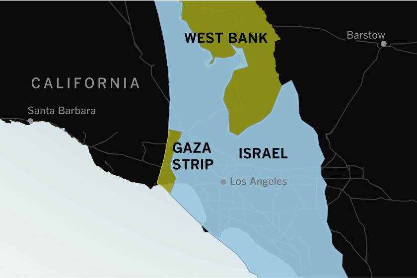
Overlaying a rotated map of Israel and the Palestinian territories on Southern California can help make the distances more clear.
The entire area is smaller than the slice of California from San Diego to Fresno.
This is an imperfect comparison in many ways, as similarities in size don't mean similarities in living conditions, infrastructure, population density, demographics or geopolitics, let alone topography or access to food, water, electricity and other resources.
But looking at proximity alone, the distance between Gaza City (overlaid on Thousand Oaks) and Jerusalem (Lancaster) fits inside Los Angeles County. From this view, Tel Aviv would be closer than Bakersfield. A trip to Yosemite National Park would take you off the map entirely.
All told, Israel plus Gaza and the West Bank cover about 10,600 square miles of land — 2½ times the area of Los Angeles County.
Gaza is smaller still
On Oct. 7, the first day of the latest eruption of violence between Hamas and Israel, Hamas fired rockets that hit targets throughout Israel while militants on the ground attacked Israeli communities and a music festival close to Gaza. Israel responded the next day with airstrikes, and the conflict has continued to escalate.
To understand the scale of the violence and suffering in and around Gaza, try rotating a map of Gaza and ovelaying it on a swath of Los Angeles County. This depiction illustrates only the first two days of attacks.
Evacuation zone
Gaza is home to about 2.3 million people, half of whom live in the more population-dense northern part that includes Gaza City. On Saturday, Israel began telling the civilians in that northern area to evacuate immediately for their "own safety," signaling a potential ground offensive there.
With border crossings closed, the only place to relocate is within Gaza.
From a perspective of distances, this would be like telling everyone living in a slice of the Los Angeles area from Hollywood to Inglewood to get away by moving to a slice that covers Hawthorne through the South Bay.
Gaza covers some 140 square miles of land, less than one-third the size of the city of Los Angeles.
Looking at sizes and distances is just one way to view Israel, Gaza and the unfolding crisis. Taken together with other facts and perspectives, it can be a window into what's happening in the region.
Read more: How to think about Israel and Gaza? We asked Palestinian and Jewish leaders
Read more: What do Hamas and Israel see as the endgame? What would 'victory' look like?
Read more: How Jewish-Palestinian couples cope with a war that hits too close to home
This story originally appeared in Los Angeles Times.
