
 Yahoo Sports
 Torrential rain to hit NSW and Queensland this weekend amid wet summer outlook
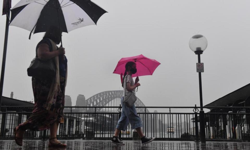
New South Wales and Queensland will see another weekend of “torrential” rainfall as dangerous flash flooding risks hitting already drenched areas.
The immediate forecast came as the Bureau of Meteorology released its summer outlook on Thursday, predicting high rainfall to lash eastern, northern and central parts of Australia until February, with Queensland to bear the brunt of the rain.
The BoM meteorologist Dean Narramore said the heavy rainfall was expected to move through western and southern NSW later on Thursday before passing into south-east NSW on Friday.
“Severe thunderstorms are expected in the coming days and heaps of rivers are already experiencing flooding,” Narramore said.
Related: Australia ‘primed for flooding’: back-to-back La Niñas points to summer of wet weather perils
“Some inland hail might occur but the main risk is very, very heavy rainfall leading to dangerous flash flooding, and damaging winds. Further rivers are likely to flood.
“It’s going to be a wet and stormy few days.”
Severe thunderstorm warnings were in place across Victoria, NSW, Queensland and parts of the Northern Territory on Thursday, while there were more than a dozen flood warnings in place across NSW and Queensland.
Several rivers in NSW including the Lachlan were already flooding as a result of previous storms. Dams across the state were at 94% of total storage capacity, a 0.4% increase on the previous week.
The Burrendong Dam was at 126.4% capacity, while the Menindee Lakes were at 110.8% total storage capacity.
“We could see them be really impacted by heavy rainfalls … and numerous other rivers could see minor to moderate flooding,” Narramore said.
Isolated showers and thunderstorms were expected to extend from Darwin in the north to eastern Victoria in the south in the coming days, impacting about a third of the nation.
“It’s not some massive band of heavy rain everyone’s going to get, but most of the eastern parts of Queensland, NSW and Victoria will see showers and thunderstorms,” Narramore said.
Peak rainfall was expected to occur on Friday, with isolated heavy falls in excess of 100mm predicted for eastern parts of Queensland and NSW.
Bundaberg, south of Gladstone had already seen 122mm of rain on Thursday, with more on the way before an eventual easing by the weekend.
Widespread eastern parts of Australia had seen between 20 and 50mm of rain on Thursday afternoon.
Email: sign up for our daily morning briefing newsletter
App: download the free app and never miss the biggest stories, or get our weekend edition for a curated selection of the week's best stories
Social: follow us on YouTube, Facebook, Instagram, Twitter or TikTok
Podcast: listen to our daily episodes on Apple Podcasts, Spotify or search "Full Story" in your favourite app
Sydney and Brisbane were expected to see between 50 and 100mm of rain in the coming three days, while Melbourne would largely miss out on the downpour. Parts of eastern Victoria were likely to see between 25 and 50mm of rain.
“It’s good news if you don’t want it,” Narramore said. “Melbourne will just get occasional light, drizzly showers.”
The heaviest storms were expected to ease by the weekend, with some showers still to pass through NSW and Queensland.
Narramore said if you didn’t like humid, sticky weather, you weren’t in luck, as there was “a lot more to come” in the following weeks and months.
“Nothing in weather is constant, but it’ll be wet and stormy through Sydney and Brisbane and there’s no long sunny stretch on the way yet,” he said.
Related: What is the meaning of La Niña and how will the weather event affect Australia’s summer?
This year’s spring was likely to be the wettest since 2016, while this month was to be among the 10 wettest Novembers on record for NSW and South Australia.
The higher than average rainfall was expected to continue throughout summer as La Niña in the Pacific Ocean combined with the positive Southern Annular Mode (SAM).
La Niña was officially declared by the BoM on Tuesday, following weeks of wild weather in eastern parts of the nation.
The bureau’s head of operational climate services, Dr Andrew Watkins, said warmer waters in the west coupled with increased moisture was likely to create wet conditions for parts of Australia’s east coming into summer.
“La Niña … is now established in the Pacific Ocean for the second year in a row,” he said.
“December is likely to see our typical summer weather systems pushed further south than normal, meaning more humid air coming off the Tasman Sea, and into NSW and eastern Victoria.
“Spring has been wetter than normal and, as a result, soil moisture is high, water storages are full, and we’ve seen flooding in some areas. Any additional rain on our already wet landscape will increase the flood risk for eastern Australia this summer.”
But despite high rainfall, temperatures were also forecast to be warmer than average across most of Australia this summer, except the south-east.
Minimum temperatures were also predicted to be above average, though below average daytime temperatures were expected for eastern NSW.
There were no strong swings to wetter or drier conditions in South Australia, while parts of Western Australia were likely to see above or slightly above average rainfall.
While there was below average fire potential in many forest areas in NSW and eastern Victoria, Watkins said strong grass and crop growth over spring could dry out during summer, increasing fire risk.
