
 Yahoo Sports
 It’ll feel like over 100 degrees in Bradenton and Sarasota next week, forecasters say
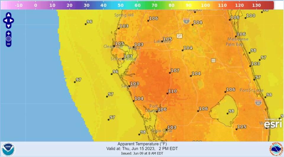
Summer is officially here as Memorial Day weekend has passed and the weather forecast shows heat indexes over 100 degrees next week — some over 103.
Beginning Tuesday, conditions are expected to dry out and heat up across Southwest Florida, including Bradenton and Sarasota, said National Weather Service Tampa meteorologist Ali Davis.
That’ll bring actual temperatures in the mid-90s, which combined with about 50% humidity, will feel like over 100 degrees by the end of the week.
It’ll be hottest in inland areas away from the coast like eastern Manatee County, where there’s less sea breeze.
“We could see anywhere from 102 to 104 for a few hours each afternoon,” she said.
By Thursday and Friday, some central areas like Highlands County could see heat indexes over 105.
Bradenton-area heat index over 100 next week
Davis said it’s common to see some of the hottest weather during the beginning of summer. Although the rainy season has started — and fertilizer bans are in effect as of June 1 — it’s not yet in full swing.
“We don’t have the rain and the clouds and moisture to help keep the temperatures down (next week),” she said.
It’s predicted to be only slightly warmer than the average June temperatures, which are usually in the low 90s.
Manatee County and surrounding areas also have been in a severe drought, but the start of the rainy season has helped and it’s now in moderate drought territory.
Manatee County weather forecast
Saturday: Scattered showers and thunderstorms after 2 p.m. Sunny, with a high near 93. Heat index values as high as 100. Calm wind becoming south-southwest around 6 mph in the afternoon. Chance of precipitation is 50%. New rainfall amounts of less than a tenth of an inch, except higher amounts possible in thunderstorms.
Saturday night: Scattered showers and thunderstorms, mainly before 8 p.m. Mostly clear, with a low around 71. West wind 5 to 7 mph becoming calm after midnight. Chance of precipitation is 30%.
Sunday: Scattered showers and thunderstorms after 2 .. Sunny, with a high near 93. Calm wind becoming southwest 5 to 8 mph in the morning. Chance of precipitation is 40%.
Sunday night: Scattered showers and thunderstorms before 8 p.m. Mostly clear, with a low around 71. West wind 5 to 9 mph becoming light southwest after midnight. Chance of precipitation is 30%.
Monday: Scattered showers and thunderstorms after 2 p.m. Sunny, with a high near 94. West southwest wind 5 to 10 mph. Chance of precipitation is 30%.
Monday night: Scattered showers and thunderstorms before 8 p.m. Mostly clear, with a low around 72. West southwest wind 5 to 10 mph. Chance of precipitation is 30%.
Tuesday: Scattered showers and thunderstorms after 2 p.m. Sunny and hot, with a high near 95. West wind 6 to 13 mph, with gusts as high as 18 mph. Chance of precipitation is 30%.
Tuesday night: Scattered showers and thunderstorms before 8 p.m. Mostly clear, with a low around 72. Chance of precipitation is 30%.
Wednesday: Scattered showers and thunderstorms. Sunny and hot, with a high near 95. Chance of precipitation is 30%.
Wednesday night: Scattered showers and thunderstorms. Mostly clear, with a low around 74. Chance of precipitation is 30%.
Thursday: Scattered showers and thunderstorms. Sunny and hot, with a high near 96. Chance of precipitation is 40%.
